Monthly
This map shows the monthly geopotential height climatology and anomalies at the 250
hPa pressure level in the atmosphere using the 1991-2020 base period for the month
shown.
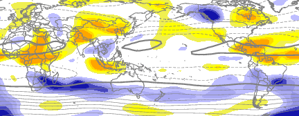
This map shows the monthly geopotential height climatology and anomalies at the 500
hPa pressure level in the atmosphere using the 1991-2020 base period for the month
shown.
This map shows the monthly geopotential height climatology and anomalies at the 925
hPa pressure level in the atmosphere using the 1991-2020 base period for the month
shown.
This map shows the monthly geopotential height climatology and standardized anomalies
at the 925, 500, and 250 hPa pressure levels in the atmosphere using the 1991-2020
base period for the month shown.
This map shows the monthly streamfunction climatology and standardized anomalies at
the 925, 500, and 250 hPa pressure level in the atmosphere using the 1991-2020 base
period for the month shown.
This map shows the monthly velocity potental climatology and standardized anomalies
at the 250 hPa pressure level in the atmosphere using the 1991-2020 base period for
the month shown.
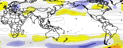
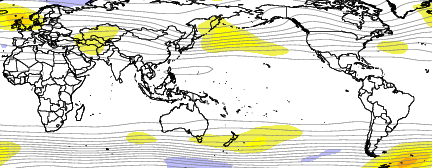
This map shows the monthly streamfunction climatology and anomalies at the 250 hPa
pressure level in the atmosphere for the given month over the 1991-2020 base period.
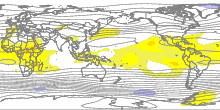
This map shows the monthly streamfunction climatology and anomalies at the 500 hPa
pressure level in the atmosphere for the given month over the 1991-2020 base period.
This map shows the monthly streamfunction climatology and anomalies at the 925 hPa
pressure level in the atmosphere for the given month over the 1991-2020 base period.
This map shows the monthly velocity potential climatology and anomalies at the 925
and 250 hPa pressure levels in the atmosphere for the given month over the 1991-2020
base period.
This plot presents a representation of the Quasi-biennial Oscillation (QBO) in terms
of a time-pressure cross-section of the spatial average of equatorial zonal winds.
This is a contour map of monthly average sea level pressure for the globe.
This is a contour map of monthly average sea level pressure anomalies for the globe
with respect to the 1991-2020 climatology.
This is a contour map of monthly average sea level pressure standardized anomalies
for the globe with respect to the 1991-2020 climatology.
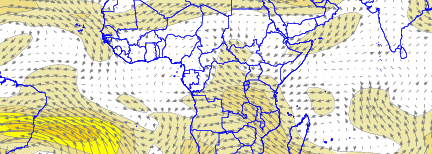
These maps show monthly vector wind anomalies at various pressure levels in the atmosphere
using the 1991-2020 base period for the month shown.
These maps show monthly vector wind anomalies at various pressure levels in the atmosphere
using the 1991-2020 base period for the month shown.
These maps show monthly vector wind anomalies at various pressure levels in the atmosphere
using the 1991-2020 base period for the month shown.
These maps show monthly vector wind anomalies at various pressure levels in the atmosphere
using the 1991-2020 base period for the month shown.
These maps show monthly vector wind anomalies and wind speed anomalies from the month
previous (Lag = -1) to the labeled month, and the change in sea surface temperature
anomalies from the previous month to the labeled month, for the globe, using the 1991-2020
base period.
These maps show monthly vector winds, wind magnitudes, and sea surface temperatures
for the globe for the month shown.
These maps show monthly vector wind anomalies, wind speed anomalies, and sea surface
temperature anomalies for the globe using the 1991-2020 base period for the month
shown.
Daily
This map shows a 90-day animation of thirty-day average geopotential height and anomalies
at the 250 hPa pressure level in the atmosphere using the 1991-2020 base period.
This map shows a 90-day animation of thirty-day average geopotential height and anomalies
at the 500 hPa pressure level in the atmosphere using the 1991-2020 base period.
This map shows a 90-day animation of thirty-day average geopotential height and anomalies
at the 925 hPa pressure level in the atmosphere using the 1991-2020 base period.
This map shows a 90-day animation of thirty-day average geopotential height and standardized
anomalies at the 250 hPa pressure level in the atmosphere using the 1991-2020 base
period.
This map shows a 90-day animation of thirty-day average geopotential height and standardized
anomalies at the 500 hPa pressure level in the atmosphere using the 1991-2020 base
period.
This map shows a 90-day animation of thirty-day average geopotential height and standardized
anomalies at the 925 hPa pressure level in the atmosphere using the 1991-2020 base
period.
This map shows the thirty-day average geopotential height climatology and anomalies
at the 250 hPa pressure level in the atmosphere using the 1991-2020 base period for
the latest available thirty-day period.
This map shows the thirty-day average geopotential height climatology and anomalies
at the 500 hPa pressure level in the atmosphere using the 1991-2020 base period for
the latest available thirty-day period.
This map shows the thirty-day average geopotential height climatology and anomalies
at the 925 hPa pressure level in the atmosphere using the 1991-2020 base period for
the latest available thirty-day period.
This map shows the thirty-day average geopotential height climatology and standardized
anomalies at the 250 hPa pressure level in the atmosphere using the 1991-2020 base
period for the latest available thirty-day period.
This map shows the thirty-day average geopotential height climatology and standardized
anomalies at the 500 hPa pressure level in the atmosphere using the 1991-2020 base
period for the latest available thirty-day period.
This map shows the thirty-day average geopotential height climatology and standardized
anomalies at the 925 hPa pressure level in the atmosphere using the 1991-2020 base
period for the latest available thirty-day period.
Seasonal
This map shows the seasonal (3-month average) geopotential height climatology and
anomalies at the 250 hPa pressure level in the atmosphere using the 1991-2020 base
period for the season shown.
This map shows the seasonal (3-month average) geopotential height climatology and
anomalies at the 500 hPa pressure level in the atmosphere using the 1991-2020 base
period for the season shown.
This map shows the seasonal (3-month average) geopotential height climatology and
anomalies at the 925 hPa pressure level in the atmosphere using the 1991-2020 base
period for the season shown.
These maps show the seasonal geopotential height climatology and standardized anomalies
at the 250, 500, and 925 hPa pressure levels in the atmosphere using the 1991-2020
base period for the season shown.
This map shows the seasonal (3-month average) streamfunction climatology and standardized
anomalies at the 250, 500, and 925 hPa pressure levels in the atmosphere using the
1991-2020 base period for the season shown.
These maps show the seasonal (3-month average) velocity potental climatology and standardized
anomalies at the 925 and 250 hPa pressure levels in the atmosphere using the 1991-2020
base period for the season shown.
This map shows the seasonal (3-month average) streamfunction climatology and anomalies
at the 250 hPa pressure level in the atmosphere using the 1991-2020 base period for
the season shown.
This map shows the seasonal (3-month average) streamfunction climatology and anomalies
at the 500 hPa pressure level in the atmosphere using the 1991-2020 base period for
the season shown.
This map shows the seasonal (3-month average) streamfunction climatology and anomalies
at the 925 hPa pressure level in the atmosphere using the 1991-2020 base period for
the season shown.
These maps show the seasonal (3-month average) velocity potental climatology and anomalies
at the 925 and 250 hPa pressure levels in the atmosphere using the 1991-2020 base
period for the season shown.